The children are wearing short trousers and white
shirts – it is summer of 1941. There is a pleasant atmosphere in the picture,
geese are
grazing in the small clearing behind the brook. There is no sign that
within a year all this will not exist any more.
In
the years following and until the end of the war, all that was left of
old Lidice was an empty plain and a few trees. The back road from
Buštěhrad by the cemetery which
used to lead straight to the first houses in Lidice, suddenly turned southwest
by “Salvator” after the war, to
the edge of new Lidice, (by walnut tree
alley), and descended down to the meadow where it formed a dam. The
road is finished on the
crossroads between Makotřasy and Hřebeč.
- - -
Nowadays, the
whole valley is surrounded by mixed woods which were planted on the edges
of where the last houses in the old village were,
actually at the end of each garden belonging
to each house.
The exceptions
are the woods behind the cemetery towards Hřebeč and younger thick
pine trees growing by the roadside next to the new
cemetery, towards a lake called “Nervák”.
When the Morigl company levelled the village with explosives and RAD
finished removal work, there were no fruit trees or bushes left anywhere
in the village. They were removed so that no one could ever
remember where Lidice used to be. Even the brook’s bed they moved northerly
by
almost 15 meters. (1)
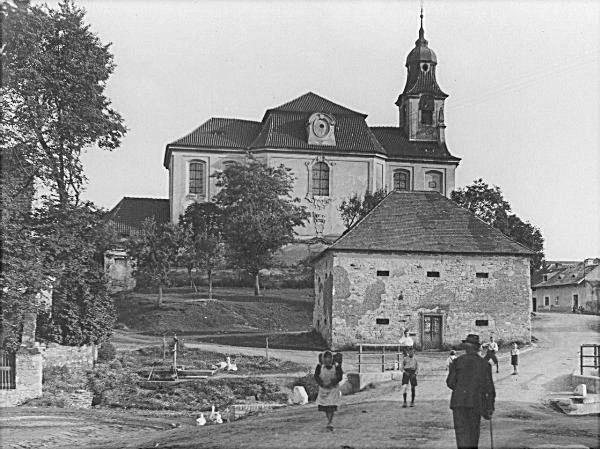
From where has appeared the fully grown
pear tree in the Piet territory? In the old photograph with church there
is the pear tree visible as a
sapling.
The orientation point for this assumption was provided by a hole in the lid of what used to be communal well, which has been preserved and is positioned from the tree less than 4 meters away.
It is possible
to see a sapling right in the area where today’s pear tree grows in other
post war photographs in the book “Lidice how we
used
to know them”
written by Doctor Quido Jeřábek.
Mrs Peková and Mr Vandrle, the communal policeman,
planted 3 pear trees nearby the communal well.
One on the right side towards the granary and the second one slightly
to the left towards school, along the road leading from
the little bridge towards school and Šilhán’s farm. Both pear trees
were further from the brook than the communal well with hand pump and
both are noticeable on the mentioned photograph.

Communal
pump – a cast iron cylinder approximately 150 cm high, with outer
pipe in the middle of its height leading to a spout on the end of
which a bucket would be hung or wooden tub put under. Water was pumped
with help of the arm, the same way as today. The pump spout on
the photograph is oriented towards the
brook and therefore northerly. It is necessary to add, that before the
war the pump was right beside the
brook. Tubs were rinsed with a bit of
water from the brook then the water would be poured straight back into
it.
- - -
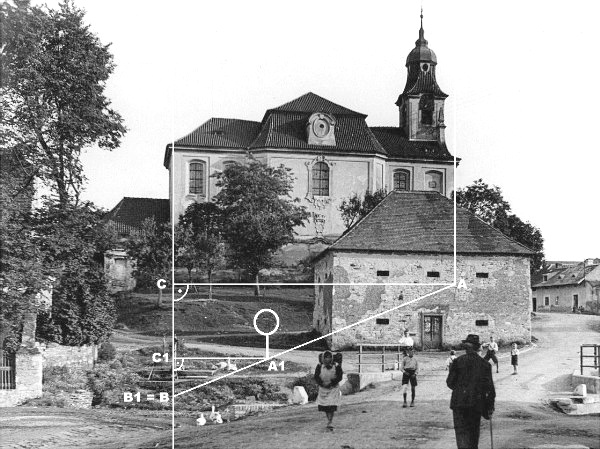
With help of a tape measure and string with marker stakes , I have found the place where the photographer stood and from that it was easy to prove the assumption that the pear tree stands on its original spot.
The church in the photograph is visible
from where the photographer stood at such an angle that the eastern
church wall between the nave and the vestry that extends downwards
to the valley lies almost covering the view of the pump (the gutter
on the east side of the roof is also
blocked from view). The photographer must have at that time stood nearly
exactly north of the church on the border of the eastern wall and
vestry.
According to the measured angles and
distances from the photograph, the conclusion is that today’s pear tree
is standing on the same spot
as the pear tree which was planted by Mrs Peková nearest to the communal
well.
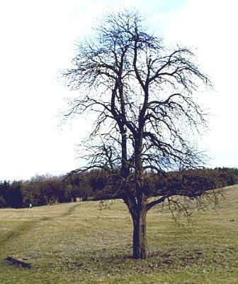
During the church and granary demolition,
the top of the original pear tree sapling was broken off, the lump on the
pear tree at about breast
height indicates that. The pear tree is not wild because it has big
healthy fruit.
Mrs Anna Peková provided me with
the necessary information in 2001 and confirmed my assumption that it is
one of the three original
communal pear trees.
In 2006 I enquired with Kladno’s Magistrate
to get this pear tree pronounced as a protected tree and have
received notification that materials for it are prepared, and that discussion
about it will start at the end of April 2007.
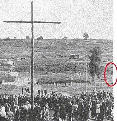
In the period photographs a small pear tree can be seen shortly
after the war.
Photo: Antonín Nešpor 2001
Click
here for map positioning ![]()
Written in Lidice on 14th of April 2007 Antonín Nešpor
(1) If you use viewing of portal mapy.cz
Click
here for map positioning![]() it is possible to look at the same place where the pear tree is
standing and also in historic map, though at that time it was not there
yet of course (maps are from one before last century), little target shows
it is possible to look at the same place where the pear tree is
standing and also in historic map, though at that time it was not there
yet of course (maps are from one before last century), little target shows
directly onto the brook’s bank
next to the little bridge, which confirms that the Germans have moved the
brook’s bed northerly.